In recent years, LiDAR (Light Detection and Ranging) technology and artificial intelligence (AI) in drones have become one of the most important tools transforming industries such as surveying, agriculture and energy. The use of LiDAR and AI in combination with autonomous UAV (Unmanned Aerial Vehicles) systems enables precise terrain mapping, crop monitoring and energy infrastructure management on an unprecedented scale. The introduction of these advanced solutions not only streamlines operational processes, but also generates significant savings and improves the accuracy of data analysis.
LiDAR and its use in drones
LiDAR technology, based on emitting light pulses and measuring their reflection from objects, allows for precise creation of three-dimensional models of terrain and objects with high accuracy. In the context of drones, LiDAR provides the ability to quickly map terrain, which is crucial in fields such as surveying, agriculture, and energy infrastructure management. Drone-mounted LiDAR systems can operate in a variety of lighting conditions, making them much more versatile than traditional photogrammetric methods that rely on photos.
The primary advantage of LiDAR is its ability to penetrate vegetation, allowing for accurate terrain mapping, even in difficult conditions such as dense forests or thickets. Using precise distance measurement, LiDAR can generate detailed terrain data, which is crucial for surveyors, architects, and engineers. This technology allows for the collection of millions of data points in a matter of minutes, significantly reducing the time needed to conduct detailed analyses.
AI in drones – a new era of intelligent operations
Artificial intelligence (AI) in drones is playing an increasingly important role, enabling autonomous processing and analysis of data in real time. AI enables drones to not only collect data, but also to immediately process it and make decisions based on it. When combined with LiDAR systems, AI can be used to automatically classify terrain, identify objects and detect changes in infrastructure. In the surveying industry, AI can support the analysis of data collected by drones, automatically detecting differences in the terrain and indicating areas requiring intervention.
In agriculture, AI allows for precise monitoring of crop health by analyzing data obtained from multispectral and hyperspectral sensors. Automated algorithms can analyze the state of vegetation, soil moisture and identify areas susceptible to diseases or pests. In the energy sector, drones equipped with AI can monitor power lines, detect infrastructure damage and assess the risk of fires by analyzing the environment around high-voltage lines.
Surveying – a new level of accuracy
Drones with LiDAR and AI are able to provide extremely precise surveying data that previously required long and expensive field operations. LiDAR's ability to create high-resolution point clouds, combined with AI algorithms, allows for automatic detection of boundaries, terrain structure and obstacles. Thanks to this, processes related to planning infrastructure investments, building roads, bridges or analyzing landslides can be carried out faster and more accurately.
Drones with LiDAR are particularly useful in hard-to-reach places, such as mountainous areas or places with limited access to traditional measuring tools. They allow data to be obtained even in extreme terrain conditions, which significantly improves geodetic processes and reduces the costs associated with transporting heavy equipment to the measurement site.
Agriculture - precise resource management
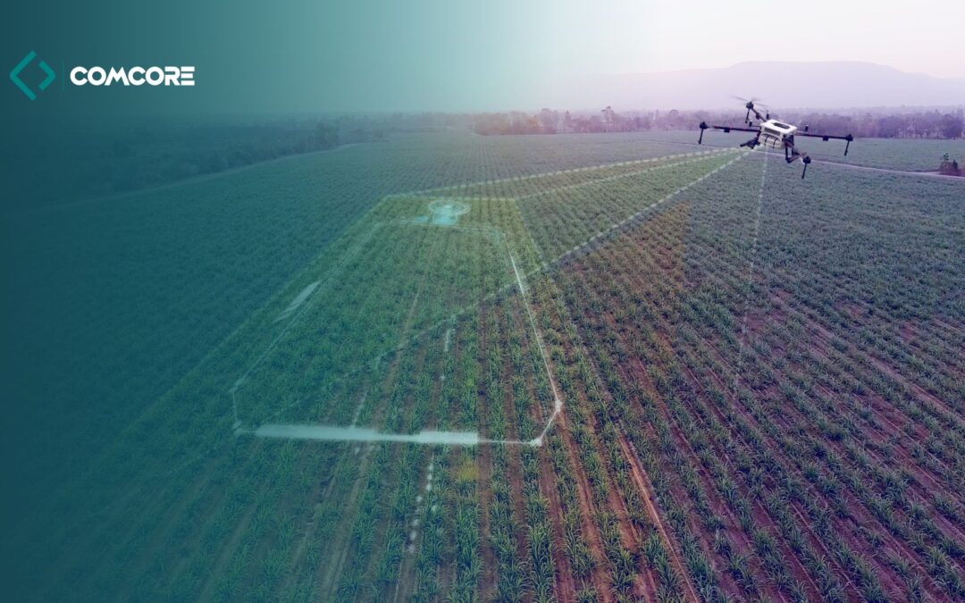
In the agricultural sector, LiDAR and AI technologies are revolutionizing the approach to resource management and crop optimization. Drones equipped with LiDAR sensors and AI systems can monitor vast agricultural areas, providing information on plant condition, irrigation needs, soil nutrient levels and fertilization optimization possibilities.
This technology allows farmers to precisely manage fields in real time. Instead of uniform application of fertilizers or pesticides, it is possible to adapt operations to the needs of individual crop areas. In practice, this means saving resources, higher yields and more sustainable agriculture. Thanks to multispectral analysis and AI algorithms, drones can also detect plant diseases at an early stage, which allows for rapid intervention and minimization of losses.
Energy – Infrastructure monitoring and management
In the energy industry, LiDAR and AI technologies are gaining importance due to their ability to monitor infrastructure such as power lines, power plants and transmission grids. Drones equipped with these technologies are able to regularly monitor the condition of infrastructure, collecting data on damage, corrosion, deformation and threats related to vegetation growing near transmission lines.
Using AI, drones can analyze collected data in real time, identifying potential problems that could lead to power outages or failures. If a threat is detected, such as vegetation getting too close to power lines, AI systems can automatically generate alerts and recommendations for preventive actions. Large-scale monitoring using drones allows for improved safety, reduced risk of failures and better management of energy resources.
The Future of LiDAR and AI in drones
The use of LiDAR and AI in drones is rapidly developing, and their potential in key sectors such as surveying, agriculture and energy is becoming increasingly visible. With progress in the miniaturization of sensors, increasing computing power and the development of advanced machine learning algorithms, the capabilities of drones in these sectors will expand even further.
In the future, we can expect even greater integration of LiDAR and AI systems with other technologies such as blockchain, which can enable even more comprehensive data management and better protection of their integrity. Industry 4.0, to which these innovations are related, is taking drones to a new level of autonomy, which not only increases operational efficiency but also creates new business models, e.g. in the field of remote infrastructure management.
LiDAR and AI in drones are becoming key tools for transformation in surveying, agriculture and energy, enabling precise mapping, resource management and infrastructure monitoring on an unprecedented scale. These advanced solutions not only increase the accuracy of operations and reduce costs, but also introduce new possibilities in the management of land, crops and energy networks. Over time, their role in the digitalization and automation of industry will only grow, introducing new standards of efficiency and safety in key industries.
LiDAR and AI technologies in drones: Groundbreaking solutions for surveying, agriculture and energy